Ever wonder what your campus may have looked like 100 years ago? What were the older buildings used for before they were part of the University? What kinds of structures were here before the new facilities appeared?
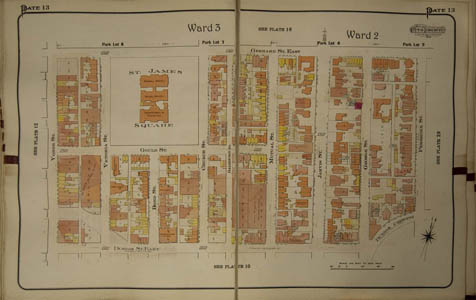
A wonderful historical resource was recently donated to Special Collections from the collection of Edward Koshchuk: The Atlas of the city of Toronto and suburbs was published in 1910 in 3 volumes, expanded from the original 1890 edition because “the City has increased so rapidly, and the area is now so much more extensive.” The atlas contains maps of the city of Toronto including the land now occupied by the Toronto Metropolitan University campus, and was revised using small pasted-in bits of paper and handwritten notations, so that the current view is actually more accurate to 1923.
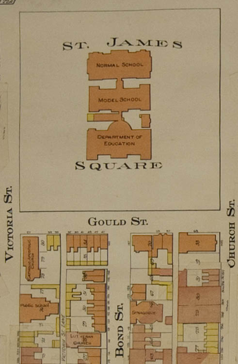
The area identified as St. James Square in the detail below is now bordered on all four sides by the endless tunnel known as Kerr Hall, and all that remains of the Upper Canada Normal School, founded by Egerton Ryerson as a Teacher’s College in 1852, is the thin façade marking the entrance to our underground gym (the RAC). These buildings survived to the 1950s, just hitting the 100 year mark before they were removed for the construction of Kerr Hall. The Archives has a diorama of the Square and the buildings shown on this map in their reading room, and more information about Ryerson campus history is also available on this website.
Of note are the many different religious houses in the area, including a Catholic Church where Lake Devo is now, a Synagogue, Lutheran Church and a Congregational Church at Bond and Dundas. The Synagogue is now a Greek Orthodox Church and the Lutheran Church is still standing, hidden behind the construction for the new Image Arts building.
Other landmarks that have changed include a former public school where the Victoria Building stands, and the O’Keefe Brewery occupying the space now filled by the Bookstore, a parking garage and a Tim Hortons. Sadly, we have to count the Empress Hotel (more recently known as “the building that Salad King was in”) as a former landmark.

If you would like to take a look at the atlas yourself (Vols. 1 & 2 only), or one of the earlier atlases of the area such as The Illustrated historical atlas of the county of York and the township of West Gwillimbury & town of Bradford in the county of Simcoe, Ont, 1878 and The Topographical and historical atlas of the county of Oxford, Ontario, 1876, please make an appointment by sending an email to asc@ryerson.ca or phone 416-979-5000 x7027.
Ryerson Catalogue Entry: http://catalogue.library.ryerson.ca/record=b2025645~S0